North Dakota
ND · Data from 2022–2023 government sources · Midwest
North Dakota, the Peace Garden State, is a sparsely populated Great Plains state with wide-open skies, a booming energy sector, and the ruggedly beautiful Badlands that inspired Theodore Roosevelt's conservation legacy. Despite being one of the least-visited states, North Dakota offers authentic frontier heritage, one of the lowest unemployment rates in the nation, and a quality of life that consistently ranks among the best.
Think you know North Dakota? Test your geography skills.
History
North Dakota was home to the Mandan, Hidatsa, and Arikara nations, who built sophisticated earth lodge villages along the Missouri River. Lewis and Clark spent the winter of 1804-05 at Fort Mandan, where they met Sakakawea (Sacagawea). North Dakota became the 39th state on November 2, 1889 — admitted simultaneously with South Dakota (no one knows which was technically 'first'). The state's identity was built on farming and ranching, with Scandinavian and German immigrants shaping the culture.
Economy
The Bakken oil boom transformed North Dakota's economy in the 2010s, making it the second-largest oil-producing state (after Texas). Agriculture remains foundational — North Dakota is the top U.S. producer of spring wheat, durum wheat, sunflowers, dry beans, flaxseed, and honey. The state has one of the lowest unemployment rates and highest per-capita incomes in the nation. Wind energy is growing rapidly across the plains.
Geography & Landmarks
North Dakota covers 70,698 square miles of prairie, river valleys, and badlands. The terrain rises gradually from east to west. The Red River Valley in the east is extremely flat and one of the most fertile agricultural regions in the world. The Missouri River bisects the state, with Lake Sakakawea (behind Garrison Dam) being one of the largest man-made lakes in the U.S. Theodore Roosevelt National Park in the western Badlands features colorful buttes, bison herds, and wild horses. The park preserves 70,447 acres of dramatically eroded buttes, canyons, and grasslands that the future president described as the land of vast silent spaces. The Drift Prairie in eastern North Dakota contains some of the richest agricultural soil in the world, formed by glacial deposits.
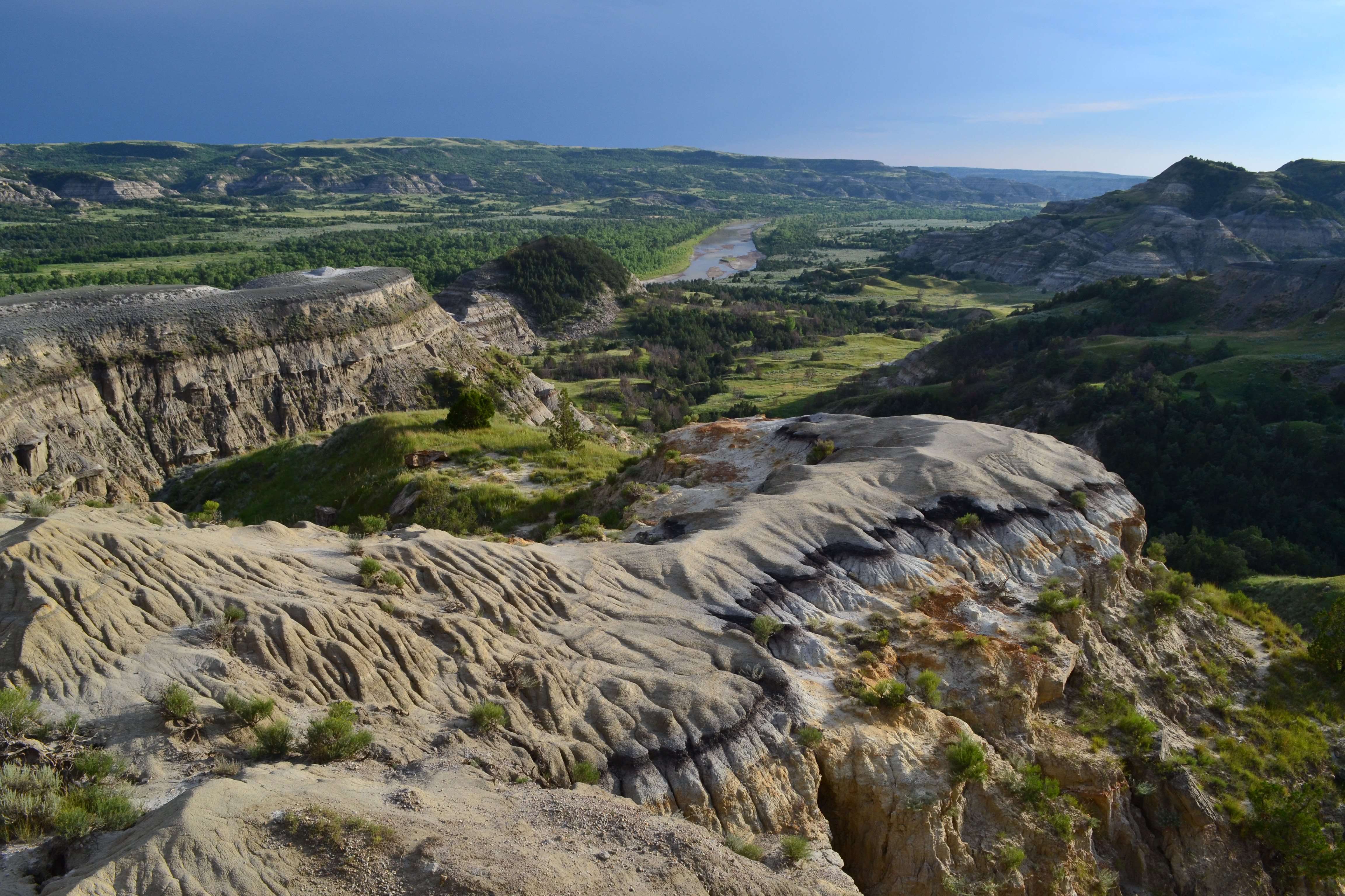
Theodore Roosevelt National Park — NPS Photo / Mark Meyers
Source: NPS API
Culture & Traditions
North Dakota's cultural traditions reflect its Scandinavian, German-Russian, and Native American heritage. The Norsk Hostfest in Minot is the largest Scandinavian festival in North America, celebrating Norwegian, Swedish, Danish, Finnish, and Icelandic cultures with traditional food, music, and crafts each September. The state's culinary traditions include knoephla soup (a German-Russian potato dumpling soup), kuchen (a German custard-filled pastry that is the state dessert), and lefse (Norwegian potato flatbread). The Medora Musical, performed in an outdoor amphitheater in the Badlands since 1965, draws over 100,000 visitors each summer with a variety show celebrating the spirit of the Old West. The Plains Art Museum in Fargo is the largest art museum in the state and features significant collections of Native American art. North Dakota State University's football program has won the most FCS national championships in the modern era, with 9 titles since 2011.
Notable Cities
Bismarck
CapitalThe state capital on the Missouri River. Named after German Chancellor Otto von Bismarck to attract German immigrant investment in the Northern Pacific Railroad.
73,694
Population
$76,014
Median income
$283,800
Home value
$969
Median rent
38.0
Median age
3.1%
Unemployment
65.4%
Homeownership
13,243
Bachelor's+
Fargo
North Dakota's largest city, on the Minnesota border. Home to North Dakota State University and a growing tech startup scene. Yes, the Coen Brothers film was (mostly) not filmed here.
Grand Forks
Home to the University of North Dakota and a major U.S. Air Force base. Known for the devastating 1997 flood and the city's remarkable recovery.
Minot
Known as 'Why Not Minot?' and the Magic City. Home to Minot Air Force Base and the annual Norsk Hostfest, the largest Scandinavian festival in North America.
Medora
A charming frontier town at the entrance to Theodore Roosevelt National Park. The outdoor Medora Musical draws visitors every summer.
Capital city data: Census Bureau ACS 5-Year (2022)
Intel File · Fun Facts
North Dakota produces more sunflowers than any other state — about 50% of the nation's crop.
Theodore Roosevelt credited his time ranching in the North Dakota Badlands with making him the man — and conservationist president — he became.
North Dakota and South Dakota were admitted as states on the same day (November 2, 1889). President Harrison shuffled the papers so no one would know which was signed first.
The geographic center of North America is near Rugby, North Dakota.
North Dakota has more wildlife refuges (63) than any other state.
Data & Statistics
Demographics
- Population
- 776,874
- Median income
- $73,959
- Median age
- 35.4
- Median home value
- $232,500
- Below poverty line
- 80,810
- Bachelor's degree+
- 113,131
Source: U.S. Census Bureau, ACS 5-Year Estimates (2022)
Agriculture
- Total farms
- 25,068
- Cropland
- 26,260,012 acres
- Market value
- $12,139M
Source: USDA NASS, Census of Agriculture (2022)
Public Health
- Obesity rate
- 35.6%
- Diabetes rate
- 9.5%
- Smoking rate
- 13.4%
- High blood pressure
- 31.8%
- Uninsured
- 4.7%
Source: CDC BRFSS Prevalence Data (2023, 2022 fallback)
National Parks & Sites
- National parks
- 1
- Total NPS sites
- 5
- Sites
- Fort Union Trading Post National Historic Site, Knife River Indian Villages National Historic Site, Lewis & Clark National Historic Trail, North Country National Scenic Trail, Theodore Roosevelt National Park
Source: National Park Service API
Climate
- Avg temperature
- 41.7°F
- Avg high
- 52.9°F
- Avg low
- 30.1°F
- Annual precipitation
- 18.0 in
- Annual snowfall
- 38.4 in
Source: NOAA Climate Normals (2010)
Frequently Asked Questions
What is the capital of North Dakota?▾
Bismarck is the capital of North Dakota. It is located on the Missouri River and was named after German Chancellor Otto von Bismarck in 1873 to attract German immigrant investment.
What is the Bakken oil field?▾
The Bakken Formation is a massive shale oil deposit beneath western North Dakota and eastern Montana. Advances in hydraulic fracturing (fracking) made the oil economically extractable starting around 2008, triggering a boom that made North Dakota the second-largest oil-producing state in the U.S.
What is Theodore Roosevelt National Park?▾
Theodore Roosevelt National Park in the western North Dakota Badlands preserves the rugged landscape where young Theodore Roosevelt ranched in the 1880s. The park features colorful painted canyon buttes, bison, wild horses, and prairie dog towns across three units.
How cold does North Dakota get?▾
North Dakota is one of the coldest states, with winter temperatures regularly dropping below -20°F. The record low is -60°F (recorded in Parshall in 1936). Blizzards and wind chill can make conditions even more extreme on the open plains.
Data sources
U.S. Census Bureau · USDA NASS · CDC BRFSS · National Park Service · NOAA CDO
This product uses the Census Bureau Data API but is not endorsed or certified by the Census Bureau. This product uses the NASS API but is not endorsed or certified by NASS.
Test your knowledge →
Play today's GeoProwl daily challenge — 10 states, 3 clues each, powered by real data.